Find Places.
Explore The
World.
Search locations, get directions, explore nearby places and navigate your world with ease.

Accurate Maps
Get precise maps and real-time updates for every location.
Easy Navigation
Step-by-step navigation to reach your destination quickly.
Explore Nearby
Discover top places and hidden gems around you.
Works Everywhere
Access maps on any device, anytime, anywhere.
How It Works
Explore the world with a smarter navigation experience in just three simple steps.
Project Mepping
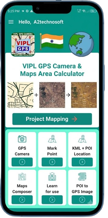
The Map Area View is the main screen of VIPL GPS Camera — a complete mapping toolkit that brings drawing, measuring, marking, project design, image overlays and cloud sync into one place. It runs on a live satellite/hybrid map with GPS tracking, real-time address display, and Google Places search. POI Mode lets you drop a single pin anywhere, drag it to set the exact position, and save it with a custom name. Each POI shows its address, supports share via Google Maps link or KML export, and can be shown, hidden, edited or deleted. Mark Point Mode works for multiple related points — you plot several pins, save them as a named group, and each point appears with a red marker and group label. In the drawer, saved groups appear with blue pins and full share/export/delete support. Area Drawing lets you draw any polygon — a farm, plot or building — with automatic area and perimeter calculation in real time. You can drag vertices to reshape, tap red midpoints to insert new points, change the polygon colour, and toggle per-side distance labels or cumulative point distances. A built-in Calculator popup handles quick math. Distance Measurement measures any route by tapping points along the way. Every segment distance and the total length update instantly, with cumulative point labels available. A powerful PDF export fits all points on the map, adds serial-numbered markers, fetches the address of every point, and saves a complete report to your Downloads folder. Project Mapping is the full irrigation design tool. You place four source point types — Water Source, Head Unit, Valve, and T-Valve — then draw pipeline lines with name, pipe type, thickness and colour. A Divide Line tool places markers at regular intervals to show where joints should go. Projects export as PDF or KML and appear in the drawer with line count and total pipeline length. Map Image Overlay lets you import a custom map image from the gallery, position it precisely on the map with drag, pinch, rotate and opacity controls, and save it as a permanent overlay. A vertical opacity slider lets you fade any saved overlay. A unit bar switches between seven area units (m², ft², yd², acres, hectares, km², mi²) and six distance units (cm, ft, yd, m, km, mi) at any moment. The search bar supports Google Places autocomplete, direct coordinate entry, and pasting Google Maps links. Live GPS tracking, satellite/hybrid tile toggle, and a compass reset complete the map controls. The drawer lists every saved item — Maps, Areas, Distances, Projects, POIs and Mark Points — with search, category filters, and per-item buttons for Show/Hide, Jump To, Share/Export, Edit and Delete. Each item shows its key values. Everything can be exported as PDF or KML and shared anywhere.
GPS Camera
GPS Camera is a powerful tool that captures photos and videos with live GPS coordinates, address, date, time, and a custom note — all permanently stamped onto the image. It is perfect for site visits, surveys, property documentation, construction progress, and any field work where location proof matters. When you open the camera, a live preview appears with a GPS information panel at the bottom. The panel shows a small live map of your current location, your full address, latitude and longitude, the current date and time, the app watermark, and an optional note. You can hide the panel anytime with the eye icon, or switch between the front and back camera with the flip button. Pinch with two fingers to zoom the camera, and tap the zoom label to reset it. Tap the shutter button to capture a photo. The app takes the camera picture, freezes the map at that exact moment, and shows a dialog asking for a file name, date and time, and an optional note. Everything you type appears on the final image. The app then captures a high-resolution screenshot of the whole camera view — photo plus GPS overlay — and saves it as a single JPEG with GPS EXIF metadata embedded inside. The image goes to your phone's DCIM/Camera folder and also to the app's local storage. You can also record video with the same GPS information. While recording, tap the shutter button to capture a still photo at any moment — this is saved as a separate GPS image without stopping the video. When you stop recording, the app shows the same file name dialog, then merges a GPS overlay panel onto the video using a native video composer — so the final MP4 shows the live map and GPS details throughout. A thumbnail is generated automatically and the video is saved to your phone. GPS Camera also includes a saved images gallery. You can view all captured photos and videos in grid or list view, select multiple items, share them with or without location links, or delete them with confirmation. Videos open in a full-screen player with play, pause, seek, and share buttons. The app also offers a GPS Edit Images feature that lets you add the same GPS panel to any existing photos from your gallery — with automatic or manually selected location. And a Template option lets you customise the panel layout and map style.
Mark Point
Mark Point is a powerful map tool that lets you drop multiple pins on any location, save them as a named group, and manage them easily. It is ideal for marking survey points, poles, boundaries, test locations, or any set of related spots on the map. You start by tapping anywhere on the map to drop a pin. Each tap adds a new point shown as a red pin. You can drag any point to fine-tune its exact location — it moves smoothly with your finger just like the POI marker. Tapping a point turns it orange to show it is selected, and the map locks so you don't accidentally move it. Tapping an empty area deselects the point. You can also undo the last added point or clear all draft points with a confirmation dialog. Once you have added all the points you need, tap the save icon. A dialog asks for a name — if left empty, the app auto-generates one using a serial number system. The group is uploaded to the server and appears in the drawer as a saved mark point group. Saved groups are displayed on the map with blue pins. Each pin has a label above it showing the group name and point number, like "Survey Points • 1", "Survey Points • 2". When you tap a saved group's pin, the whole group highlights — pins turn yellow and enlarge. Tapping the map again removes the highlight. The drawer shows all saved mark point groups with name, point count, and four action buttons — Show/Hide, Go To, Share, and Delete. Share lets you send a Google Maps directions link or export the group as a KML file for Google Earth. The map supports Google Places search, pasting Google Maps links, satellite and hybrid views, compass reset, and a "My Location" button that centres on your live GPS position. In one line — Mark Point lets you plot, save, and manage multiple related locations as a single group with names, labels, and full share/export support — perfect for surveys, field work, and location tracking.
KML + POI Location
KML + POI Location is a powerful map feature that lets you open, view, and manage KML/KMZ map files while also saving and organizing your own Points of Interest on top of them. KML is the standard map file format used by Google Earth and other GIS tools, while KMZ is its compressed version. Both are fully supported. You can import multiple KML/KMZ files at once from your phone, and they load as separate layers on a live satellite map. The app reads all points, lines, polygons, colours, icons, labels, and distances from each file — and for KMZ files, even the embedded images and custom markers appear correctly. Each file shows its name, type, and size in the drawer, where you can hide, show, share, zoom to, or delete it anytime. On top of these maps, you can mark your own POIs. Just tap anywhere, drag the pin to fine-tune the position, and save it with a custom name. Every POI is stored on the server, appears with a label on the map, and shows its full address in real time. You can show/hide, jump to, share, export as KML, or delete any POI with a single tap. The app supports Google Places search, Google Maps link pasting, direct coordinate entry, satellite and hybrid views, compass reset, and live GPS location. The drawer organizes everything into POI and KML/KMZ sections with search and filter options. This feature is perfect for land surveys, irrigation planning, field work, travel, infrastructure projects, and government mapping — combining professional map file viewing with personal location marking in one simple screen.
Maps Composer
Maps Composer is a powerful image editing tool that lets you build a custom composed map by layering multiple edited images on top of each other. It is perfect for creating land maps, property documents, and map overlays by combining several source images into one single image. You start by picking an image from your gallery. It immediately opens in a built-in eraser screen where you can clean up unwanted areas, background, or labels. The eraser offers multiple brush sizes, undo, clear-all, and a toggle between Drag Mode and Eraser Mode. You can zoom, pan, and reset the image anytime. After erasing, you can crop the image and tap Next to return it to the composer. The composer automatically converts the image into a transparent map-style overlay — light backgrounds and beige map areas become transparent, while roads, boundaries, and text stay solid. This makes it look like a clean map layer ready to stack on other images. You can add up to four layers, each shown in the top dropdown (L1, L2, L3, L4). You can select any layer, change its color, or hide the whole composition by toggling the BG button. Each layer can be moved with one finger, zoomed with two fingers, and rotated with a gesture. A floating control panel gives precise buttons for rotation, scale, and position adjustment, and the drawer shows thumbnails of all layers for quick selection. When you tap Save, the app asks for an optional file name, captures the whole composition at high resolution (4x to 12x pixel ratio), and saves it to your Pictures folder with a daily serial number like VIPLGPS_24102024_001.png. The serial resets every day for clean, organised file naming. Maps Composer turns raw map images into clean transparent overlays and exports them as a single high-resolution composed map — perfect for land records, documentation, and professional mapping work.
POI to GPS Image
POI to GPS Image is a powerful report-building feature that turns your location data and photos into professional A4-style documentation. It combines saved Points of Interest with GPS-tagged images to automatically calculate distances and create detailed visual reports — perfect for construction, surveys, irrigation, and field work. You start by creating a new report or opening an existing one from the home screen, which lists all saved reports with file name, page count, and date. Tapping "Create" opens a bottom sheet where you choose the A4 layout — Portrait or Landscape — and the composer opens to build your report. Each report contains one or more A4 pages. Portrait pages hold up to four photos (A, B, C, D) in a Before-and-After grid, while Landscape pages hold three photos (A, B, C) arranged as Before, Execution, and After. Every page has editable fields for Project Site, PBMC Agency, Chainage or Location, Work, Date, and Remarks. For each photo slot, you can capture a fresh image with the GPS Camera or pick one from your gallery. GPS Camera photos carry their coordinates automatically, while gallery images are scanned with OCR to extract printed GPS text. If no GPS data is found, the photo is still added without location. Once you select a POI from the map, you can turn on "AI Location" — the app then calculates driving distance between that POI and every image's GPS location using Google Maps Directions API. Distances appear in the Chainage field with photo labels (A. 245 m, B. 1.2 km), and you can manually add or subtract fixed distances per page. Reports can be saved to the server, shared as multi-page PDFs or page-by-page PNG images, or downloaded directly to your phone. Edit Mode lets you reopen any saved report, modify photos, headings, or pages, and update the server with only the changes. POI to GPS Image turns your POIs, GPS photos, and field data into clean, professional A4 reports — perfect for site documentation, progress reports, and government submissions.
Trusted by Millions
Built to make discovering and navigating the world simple, fast and effortless.
Take VIPL GPS
Anywhere You Go
Enjoy a seamless mapping experience wherever your journey takes you.